Rail Road Flat Weather
A Local Weather Station
 

Welcome to Calaveras County


Rail Road Flat, CA
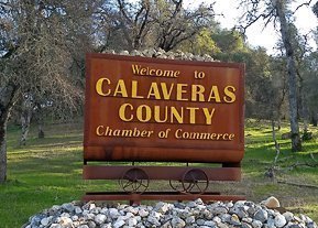
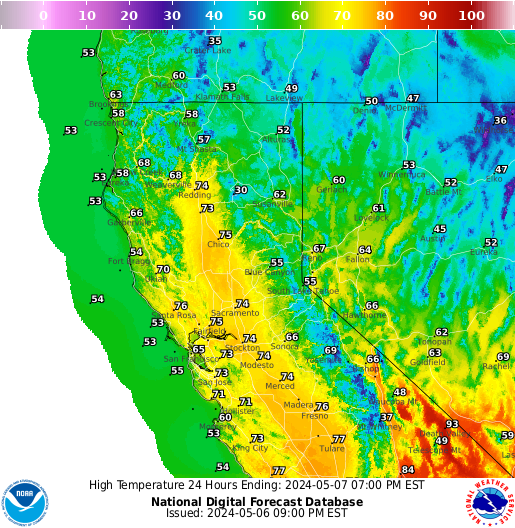
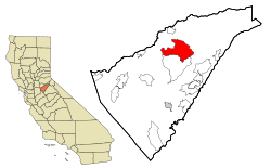
Location is the State of California in
Calaveras County

Lat 38.306N Lon -120.514W (Elev.2808 ft)


RRFWeather


Page data updates about every minute select reload to refresh...or click here Reload
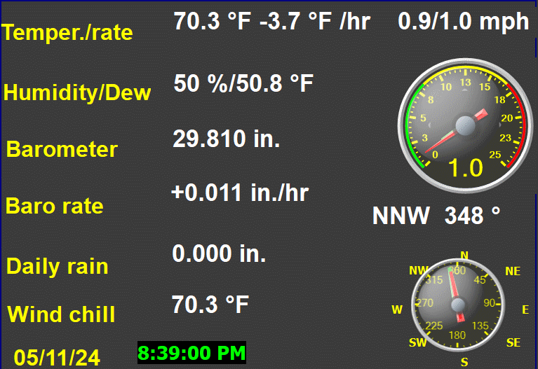
Click on above image to open the modern weather page


Chandler Burning Index
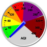
Alert Levels and Description


MRMS


AQI Chart
(click dial)

Weather Alerts

PWS Dashboard PWS Dashboard

Radar - Satellite

UV - Solar - Air Quality

Weather Vane
Overnight

Overnight: Clear
Clear
Tuesday

Tuesday: Sunny
Sunny
Lo 46 °F ↑Hi 68 °F ↓

Weather Display Live

NOAA NOAA 7 Day Forecast Rail Road Flat, CA
Intellicast Radar Intellicast SFran Doppler Radar
PG&E PG&E Weather App
Webcam Weather Cam
RRF Weather Qcode for Mobile
RRF Weather Site Map

NWS Radar

Click to open
Composit Radar
Predivtive Services - Webcast


Predictive Services - Daily Webcast
Click to enlarge
Today's Wind
The moon today
.
.
Moon Tool Star Chart
Loading PurpleAir Widget...

Air Now RRF

Fire and Smoke Map


Air Now Interactive Map


myMotherLoad.com

The PineTree.Net


Yubanet.com Logo


Calaveras Enterprise


Craigs List Gold Country


Mountain Merchant


Calaveras Visitors Bureau
Calaveras County Events Calendar


 Local Mountain Road Report


Calaveras Humane Society

Foothill Conservancy

NOAA Radio
NOAA Radio

Southwestern Weather Network


Windy.com

SPC IR/RUC/OBS 21 Layer Composite Weather Map


SPC IR/RUC/OBS Composite
21 Layer Interactive
Weather Map

pollen.com logo
Current Allergy Report
for Rail Road Flat, CA

Click to enlarge


Today's National Forecast

Click to enlarge


Today's High Temperature

Earthquakes in the past 7 days of
magnitude 2.0 or greater within 200 mi


NWS Watches, Warnings and Advisories for CA

Central Calaveras Fire-Rescue
Serving the Communities of Glencoe,
Mountain Ranch, Railroad Flat, and Sheep Ranch


Central Calaveras Fire Live Scanner
Listen Live
Central Calaveras Fire Radio

Tunein (.m3u) Primary:TCU local (San Andreas). Dispatch channel for Central Calaveras Fire and Rescue.

Brodcastify Player

Tunein
(.m3u) Calaveras and Alpine Counties Fire, Cal Fire and USFS
Direct Link


Broadcastify   Hosted by Broadcastify

Broadcastify

Calaveras County California
Live Audio Feeds


Scanner Radio Codes

World Clocks
World Clocks


Alert Wildfire
Sierra-Foothills Fire Cameras

ALERRT California

Alert California Cameras


Lightning Maps
Realtime California

Cal Fire
Wildland Fire Information


Predictive Services

NICC

InciWeb


Fire Alert MyMotherLodedotcom


Ready for Wildfire

Cal Fire Debris Burning
Cal Fire Tuolumne-Calaveras unit
lifted the ban on burning at 8 a.m.
Wednesday November 1.
Burn Day?

Burn Information: (209) 754-6600

Calaveras County Seal
Calaveras County Government
Calaveras County Assessor Parcel Map Search
Calaveras County Tax Parcel Lookup


PG&E Electrical System Outage Map
      Outage Service Line 1-800-743-5002
PG&E Public Safety Power Shutoff Event
PG&E 7-Day Public Safety Power Shutoff Forecast
PG&E Fire-detection satellites and perimeters
PG&E Weather App (cameras and weather stations)
CPUC Fire Map
Calaveras is in Fire Zone 5 Adobe Acrobat Document
NOAA Fire Weather Zone Boundaries
      (Calaveras is Zone 220)
PG&E Weather Awareness
Heatwave rotating outages status
          Rail Road Flat is in Block 50
PG&E Report It mobile app
PG&E

Public Safety Power Shutoff

Interagency Wildland Fire Air Quality Response Program
National FCAMMS Smoke Dispersion Forecast Guidance
NAM-Initialized CANSAC WRF Weather Forecasts
Current 7 Day Fire Potential Adobe Acrobat Document
Energy Release Graph (Model Y) Sierra Foothills
'Glossary of Fire Terms Adobe Acrobat Document
' Defensible Space Information
Adobe Acrobat Document
        Source - Central Calaveras Fire & Rescue

National Local Weather
NOAA's National Weather Service Glossary of Weather Terms
NWS weather page NOAA 7-Day Forecast for Lat 38.3N & Lon -120.5W (Elev. 2798 ft)
NOAA Hourly Weather Forecast for 38.34N 120.51W (Elev. 2696 ft)
NOAA 7-Day Forecast for West Slope Northern Sierra Nevada
' WeatherForYou Rail Road Flat, CA
' Weather Underground - Rail Road Flat Weather
USANet.com - Rail Road Flat Weather
' 10 Day Local Weather Rail Road Flat, CA - weather.com
The Weather Bug - Rail Road Flat Weather
AccuWeather.com Rail Road Flat Forecast
Rail Road Flat Weather Forecast and RSS Feed
GOES West IR Enhanced Satellite Loop
GOES Hemisphere 12 hr IR Satellite Loop
' Weather Conditions for ESPC1 - BANNER ROAD
      This USGS site gathers weather information,
Communty Collaborative Rain, Hail & Snow Network CA
        Click on map for counties of interest
' Eye In The Sky Webcams - myMotherLode.com
' California Weather & Traffic Webcams
USGS - Exploring Webcams
' Caltrans - Live Traffic Cams
Steel Gauges
Steel Gauges
' Calaveras County - California Zip Code Boundary Map (CA)
U.S Drought Monitor - California
WaterWatch - USGS - Map of flood and high flow condition (California)
' Rail Road Flat History
' Rail Road Flat City Data
CHP Traffic Incident Information Page
Millibars to Inches Conversion Table
Anti Spam
U.S National Debt Clock: Real Time Clock
Contact: weather at railroadflat.org


Davis Vantage Pro2


SiteUptime Web Site Monitoring Service

IP address:
52.90.181.205

Host Address:
ec2-52-90-181-205.compute-1.amazonaws.com

Browser:
claudebot

Where you came from:
http://www.railroadflat.org/index.php

Weather Display Weather Software


USA Weather Finder


Top of Page


© All rights reserved. Unauthorized duplication or distribution is prohibited
Last Update February 27, 2024